Nilometer
Tags : Nature
Time Required : 9 AM to 1PM
Ways to Experience this attraction
Nilometer, Cairo Overview
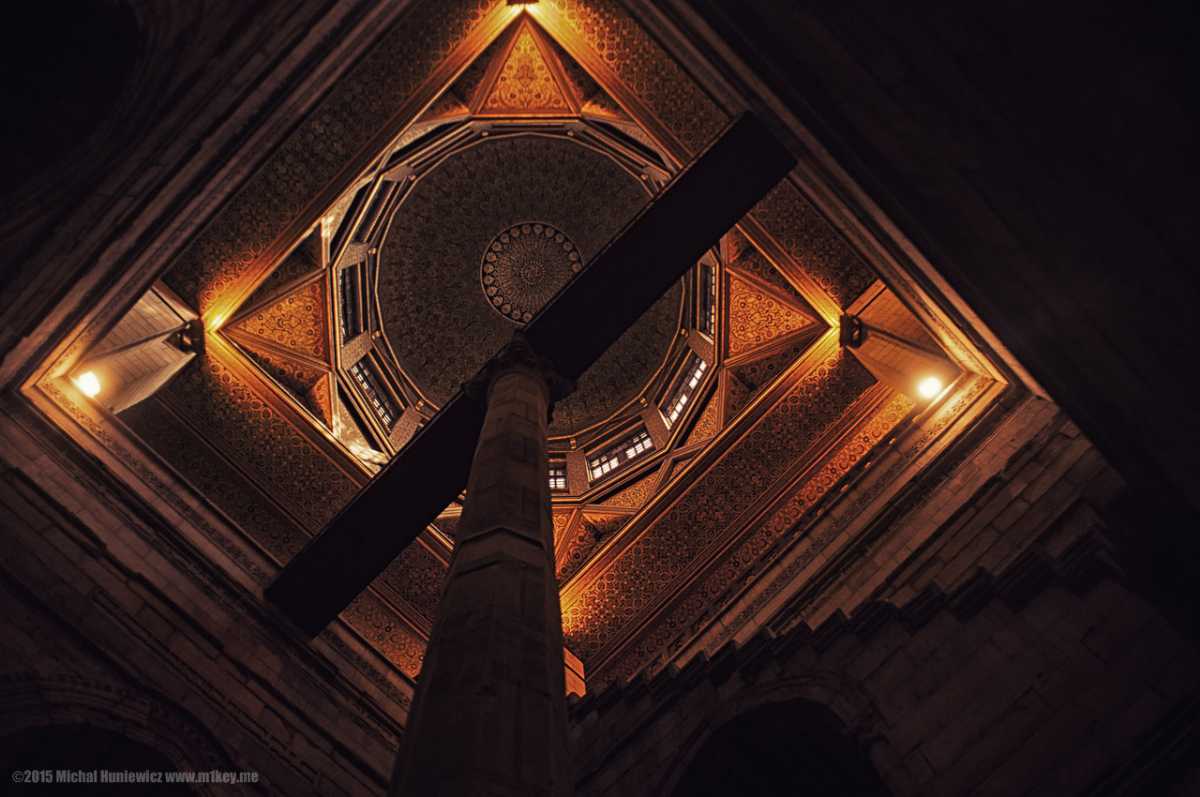
The Nilometer was used to measure the water level of the river Nile in earlier times and helped predict floods and droughts. The structure, built between the Manasterly Palace and the Um Kalthoum Museum, has a beautifully built conical dome at the top with a vertical column pillar standing in the centre, immersed in water.
Visitors can also grab a view of the coastal town of Dahab in the south of the building, feeling the cool breeze off the waters of the river Nile. People may buy tickets to the Nilometer at the entrance gate on Sharia Al Malek As Salih. One will then be accompanied by a Site Guard, who will take the visitors down the path to the Nilometer. The Site Guard is needed since the building is usually kept shut between the visits.
History of Nilometer - The Ancient Architectural Marvel of Egypt
Dating back to almost 5,000 Years ago, three Nilometer structures had been built across Egypt, with the Nilometer in central Cairo being built under the supervision of astronomer Afraganus. Situated on the southern end of the Rhoda Island in central Cairo, it consists of one of the simplest designs for measuring the level of the Nile. The Nilometer has a vertical column made of ornate stone, with markings on the column at regular intervals. Even today, one can observe these markings on the vertical column while going down the steps to the river.
It is believed that depending upon the marking up to which the water level of Nile would be, the annual harvests were predicted and the tax collection limits were decided and capped. Since the Nilometer structure was of critical importance for the Egyptians, only the priests and the ruler clans were allowed to conduct a survey of the Nilometer structure.
The Nilometer built on Rhoda Island beholds its own course of history. Earlier consisting of a hemispherical dome-shaped structure at the top, the French troops led by Napoleon Bonaparte destroyed the dome in 1825 AD during the French occupation of Egypt. When Egypt became free from French colonization, a conical dome structure was constructed on the Rhoda Island Nilometer. With the passage of time, Nilometer has undergone multiple restoration sessions in order to maintain the uniqueness of its ancient scientific structure.
Architectural Beauty of Nilometer
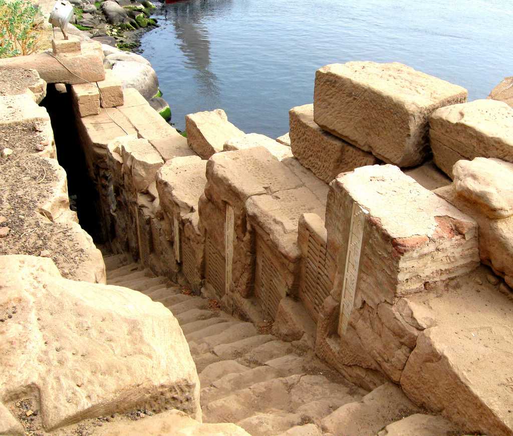
One may feel marvelled by the manner in which Egyptians deployed concepts of science in predicting the nature of river Nile upon their visit to the Nilometer in Cairo. The ancient structure consists of a long vertical pillar-shaped structure having indicative markings carved out on regular intervals. Besides this, Arabic style carvings can also be witnessed on the inner walls of Nilometer.Another Nilometer constructed on the Elephantine Island in Aswan comprises of an evenly spaced staircase leading straight down towards the river Nile. On going down the steps, one may observe the water level indicators and the corresponding markings been marked on the steps itself rather than on any vertical column. Being located in close proximity to the southern borders of Egypt, this Nilometer structure on Elephantine Island was also of utmost significance as it gave an early indication about the onset of floods in river Nile.

A third Nilometer, which happens to be situated towards the northern borders of Egypt, had markings carved out on the walls of the structure itself. The water of river Nile was brought to this Nilometer by means of a canal running along the riverbank that deposited the water into a well-shaped structure. Markings on the inner walls of the well helped in deciding the fate of the annual harvest in Egypt.
These Nilometer structures, all built under the rule of different Pharaohs of Egypt, showcase how simple architectural designs can aid in predicting events such as floods, droughts, crop harvest volume, tax collections etc. with high accuracy and precision. The most interesting thing to notice here is that Egyptians built these structures, and devised the technology to predict the nature of river Nile at a time when modern technology was not even into existence.
How to reach Nilometer
One can reach the Nilometer structure in Cairo though either of the following modes of transportation-Car/ Taxi: People eager to pay a visit to the Nilometer may do so by renting a taxi or by taking the public bus transportation services, and get down at Sharia Al Malek As Salih. Since one will have to beat the city’s traffic for reaching the place, this mode of transportation can be time-consuming.
Subway/ Metro: To reach the Nilometer via Subway, one needs to board the subway and get down at Mat Girgis Subway Station. The Nilometer lies around 3.6 Km west of the Subway Station and can be reached easily via taxi or public transportation.
Interesting Facts
The Nilometer in Central Cairo dates back to around 861 AD, which is around 5,000 Years ago!Restaurants near the Nilometer
Be it either tourists or local citizens of Cairo, one can always find a spot to dine the local cuisines of Egypt, that too on the banks of river Nile. Once the ancient scientific marvels of the Nilometer has been explored, people may find a lot of restaurants and Fast Food spots to rejuvenate themselves. Some of the restaurants close to the Nilometer are-Domino’s Pizza: Situated at a mere distance of 1.5 Km towards the north of the Nilometer, one can reach the restaurant via the Al Akhsheed Street. For this, people may also reach the restaurant by walk or y taking any of the road transportation modes.
Al Manial Restaurant: Situated near the Al Rawdah Bridge, the Al Manial restaurant is located 1.4 Km north of the Nilometer. Hence, to reach the restaurant, one will have to travel via El-Malek El-Saleh Street to be able to reach the earliest.
Casino des Pigeons: The restaurant is situated on the other side of the Al Rawdah Bridge, i.e. towards Faculty of Agriculture Cairo University. The place is around 6 Km towards the west of the Nilometer and can be reached easily via road.
Tips to Remember
Gather any sort of relevant information in context to travelling to and from the Nilometer prior to visiting the place.Read More on Nilometer
Restaurants near the Nilometer
Domino’s Pizza: Situated at a mere distance of 1.5 Km towards the north of the Nilometer, one can reach the restaurant via the Al Akhsheed Street. For this, people may also reach the restaurant by walk or y taking any of the road transportation modes.
Al Manial Restaurant: Situated near the Al Rawdah Bridge, the Al Manial restaurant is located 1.4 Km north of the Nilometer. Hence, to reach the restaurant, one will have to travel via El-Malek El-Saleh Street to be able to reach the earliest.
Casino des Pigeons: The restaurant is situated on the other side of the Al Rawdah Bridge, i.e. towards Faculty of Agriculture Cairo University. The place is around 6 Km towards the west of the Nilometer and can be reached easily via road.
History of Nilometer - The Ancient Architectural Marvel of Egypt

It is believed that depending upon the marking up to which the water level of Nile would be, the annual harvests were predicted and the tax collection limits were decided and capped. Since the Nilometer structure was of critical importance for the Egyptians, only the priests and the ruler clans were allowed to conduct a survey of the Nilometer structure.
The Nilometer built on Rhoda Island beholds its own course of history. Earlier consisting of a hemispherical dome-shaped structure at the top, the French troops led by Napoleon Bonaparte destroyed the dome in 1825 AD during the French occupation of Egypt. When Egypt became free from French colonization, a conical dome structure was constructed on the Rhoda Island Nilometer. With the passage of time, Nilometer has undergone multiple restoration sessions in order to maintain the uniqueness of its ancient scientific structure.
Tips to Remember
How to reach Nilometer
Car/ Taxi: People eager to pay a visit to the Nilometer may do so by renting a taxi or by taking the public bus transportation services, and get down at Sharia Al Malek As Salih. Since one will have to beat the city’s traffic for reaching the place, this mode of transportation can be time-consuming.
Subway/ Metro: To reach the Nilometer via Subway, one needs to board the subway and get down at Mat Girgis Subway Station. The Nilometer lies around 3.6 Km west of the Subway Station and can be reached easily via taxi or public transportation.
Architectural Beauty of Nilometer
Another Nilometer constructed on the Elephantine Island in Aswan comprises of an evenly spaced staircase leading straight down towards the river Nile. On going down the steps, one may observe the water level indicators and the corresponding markings been marked on the steps itself rather than on any vertical column. Being located in close proximity to the southern borders of Egypt, this Nilometer structure on Elephantine Island was also of utmost significance as it gave an early indication about the onset of floods in river Nile.

A third Nilometer, which happens to be situated towards the northern borders of Egypt, had markings carved out on the walls of the structure itself. The water of river Nile was brought to this Nilometer by means of a canal running along the riverbank that deposited the water into a well-shaped structure. Markings on the inner walls of the well helped in deciding the fate of the annual harvest in Egypt.
These Nilometer structures, all built under the rule of different Pharaohs of Egypt, showcase how simple architectural designs can aid in predicting events such as floods, droughts, crop harvest volume, tax collections etc. with high accuracy and precision. The most interesting thing to notice here is that Egyptians built these structures, and devised the technology to predict the nature of river Nile at a time when modern technology was not even into existence.